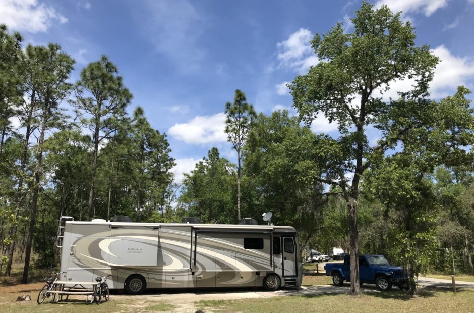
Watchman Campground, Zion National Park
If you argue your case with a neighbor, do not betray another man’s confidence, for he who hears it may shame you and you will never lose your bad reputation. ~ Proverbs 25:9-10

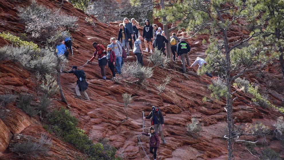
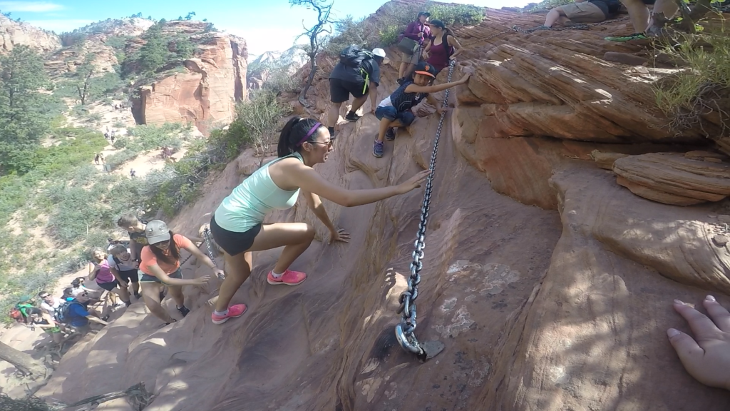
Technically, Angel’s Landing is currently closed because of the coronavirus. Angel’s Landing is a specific trail that’s labeled a “chain section”. But in order to get to the chains, you have to travel a portion of the 15-mile West Rim Trail that includes a section called “Walter’s Wiggles”. Once you reach the chain section area, you can opt to go in the opposite direction (sort of across from Angel’s Landing) to a currently open point called “Scout Lookout”.
Let’s talk history first.
When we visited Zion National Park on vacation seven years ago (or was it twelve??), we planned our trip using the wonderful travel books published by Frommer’s and Foder’s. One of the things they mentioned was hiking the Angel’s Landing Trail. I remember because I remember that I told Blaine I wasn’t doing it.
But then we got to the Park and had to sit in our car and wait before we could drive through the one-lane tunnel here (we’ll cover that another day), and since we were first in line, the Park Ranger was talking to us. She told us Angel’s Landing was a great hike and we should do it. She spent several minutes telling us it wasn’t that bad. So that made me feel like I had to do it.
When the time came, we started out. Now mind you, I was in much worse physical shape than I am today, having been ‘practicing’ steep climbs these past four months or so, so the hike itself, including Walter’s Wiggles, was a trail in and of itself. And then, we got to the chain section and I sat down to rest and watched those people walking up and down the side of a mountain. I watched young people. I watched middle-aged people (like me). I watched old people (much older than me). And I determined that if they could do it, then so could I.
Except, I couldn’t.
I tried a few steps and that was it. Blaine walked me over to the side and sat me down, and, well . . . you know those times when tears just leak out of your eyes and you can’t control it? That was me. I was immovable, but I told Blaine to go on and take pictures, and while he was gone, the chipmunks surrounded and comforted me. And I was careful to avoid eye contact with all those looking sympathetically my way.
Blaine didn’t make it all the way either. He was only gone a couple of minutes before he returned and announced that it just wasn’t worth the fall risk.
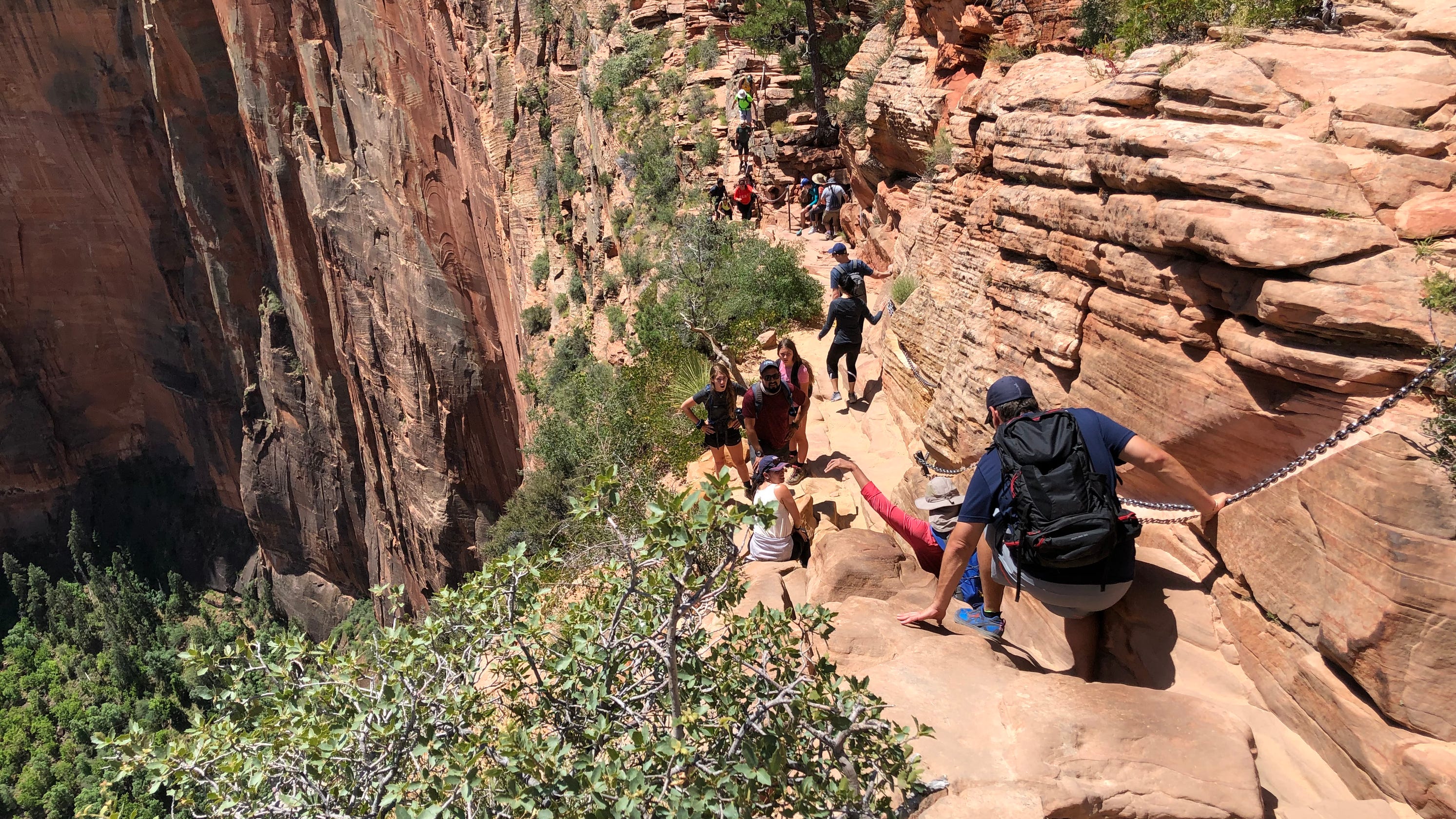
Here’s a few pictures I pulled from on-line sources, and some information to help you understand:
To get to the chain section, you first have to hike roughly 1 1/2 miles with an elevation gain of about 1,000 feet. Within a short distance. In other words, I can’t find the exact numbers, but you are basically almost vertically climbing most of the time – hence the necessity for the wiggles.
Walter’s Wiggles is a series of 21 steep zig-zags. In the beginning, they’re kinda long, but the last ones are very short and quite steep.
The Angel’s Landing chain trail was cut into solid rock in 1926. Who was crazy enough to do it, I have no idea.
They say the last 0.7 miles of the trail (the chain section) is roughly only about 4 ½ to 5 feet wide. You look at the following pictures and tell me. . . Does it look 5 feet wide to you?
Ten people have fallen to their deaths since 2004. One, in 2018, was a 13-year-old girl. The report says that she went on ahead when her extended family opted to turn around. Now seriously, how does that happen???
Wonder how many died before 2004? No one is saying.

An important note – – only the people on the inside have anything to hold onto,
and even that’s a swinging chain.
Or maybe it’s the opposite. : )
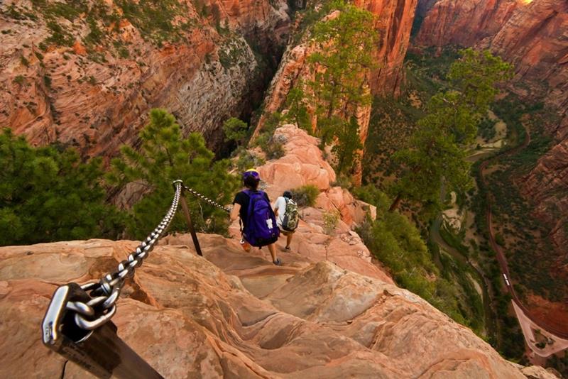
Try to remember that you’re over a thousand feet from the bottom, should you miss a step.
Or someone bumps you.
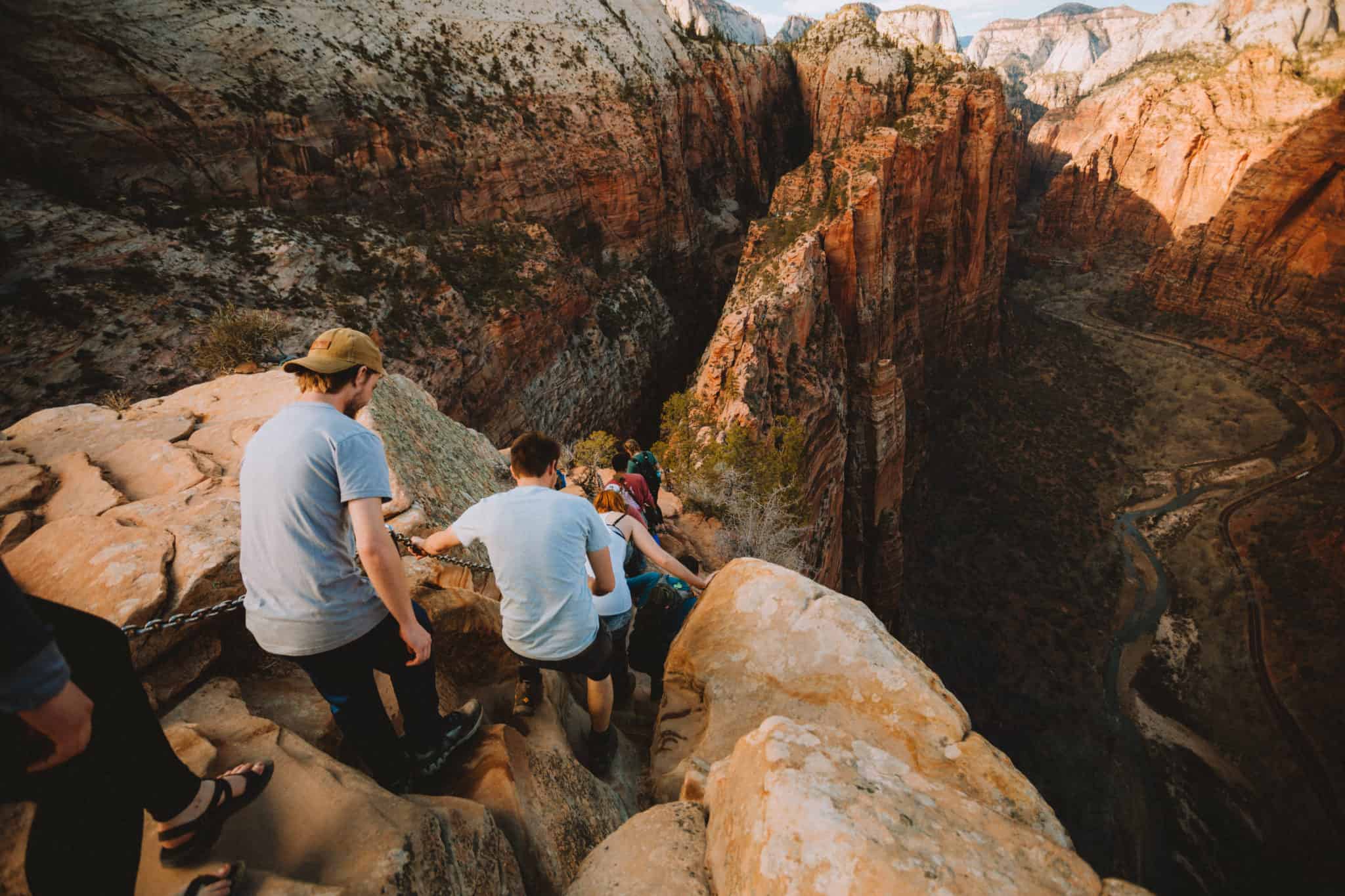


1,488′ from the bottom.

Nice, I know, but worth risking your life for?
Definitely not!
So now you know we’re not totally crazy. We were not a bit disappointed that this part of the trail was closed!
Let’s begin our actual day, where the only danger was the possibility of overheating.
We had to leave the house early today, though not as early as tomorrow will be. We were out the door around 6:30am. If you don’t leave early for this side of the Park, you’ll find yourself with no place to park. Even so, we had to park about a half mile from our trailhead, and even this early, there were quite a few hikers joining us.

That mountain is called The Watchman.

and they’re not a bit shy – – of people or cars or bikes.
We opted for a sand trail that parallels the road, rather than walking in the road to the trail head – about a ½ mile. Much nicer, and no one else was on it. 😊


I added Blaine. : )


So we crossed the bridge and fell in line behind everyone else.


Except, as it turned out, we were headed in the opposite direction from where we wanted to go. Instead, we ended up at Emerald Falls. Not so emerald, and not so falls. It was pretty dry today.

We were going to do this trail after Angels Landing, but ended up doing it first instead.


Once we realized we weren’t anywhere near Angel’s Landing, we went back to where we started to try to figure out where we went wrong.


We determined it was all in the signage. There was a sign blocking the trail that said Angel’s Landing was closed. Ah ha!

We had just walked right by the barricade without even looking at it. And remember, it’s the chain section of this trail that’s called Angel’s Landing.
So now we’re on the right track! But we’ve already put in a moderately-strenuous three-mile hike. We’ve now got about 2 ½ more strenuous miles to get to Angel’s Landing.
And since it’s several days later before I was able to work on this post, the only thing of possible interest (besides the views, of course) I can remember about this hike is to mention the countless people heading both directions on this trail.


Each of those layers of man-made rock is a switchback.


As you’ll see, there were quite a few little critter visitors looking for handouts.
It’ll cost you $100 if you’re caught feeding them.

Key word – – sitting.


Oh! I do remember something from when we were taking in the view by the closed chain section.
There was tape and large closed signs roping off the chain section. No question as to whether or not you’re allowed on the trail. But then two college-age women came down off it. And then they proceeded to talk three college-aged guys and one of their sisters/girlfriend(?) into going up. We heard them say, several times, “You should just do it! When will you ever get a chance like that again? It’s real easy when no one else is on the trail! You’ll have great views!” And so on. Meanwhile, their sister kept saying, “You promised Mom you wouldn’t go on it! Are you going to lie to her?” She also repeated forms of her admonition several times. And the one boy took off, and he was quickly followed by all but one guy and the level-headed sister. She reminded him again about their promise to their Mom, to which he replied, “Are you gonna tell?” She said, “No.” So he too, crossed the barrier.
He didn’t get far before we heard a loud, deep voice yelling, “Angel’s Landing is CLOSED!!”
It was a Park Ranger.
Three came back. The other maybe didn’t hear, or just figured ‘What’s he gonna do?’, because we didn’t see him return.
The Park Ranger planted himself on the ground, in the shade of the mountain for what we presume was the rest of his shift, to guard it against people who don’t like to follow rules. The instigating girls probably saw the Ranger on their way down and giggled. Moral of the story? Don’t listen to strange females. They’ll get you in trouble every time.

We spent quite a while in this area, looking around, and walking more of the West Rim Trail.


We just kept following the West Rim Trail. : )


Angels Landing received its name in 1916 when a group passing through the canyon
commented that only an angel could land on top of it.


We overheard the graduate girl (she was having cap and gown graduation pictures taken here) say she graduated as a Physical Therapist from OSU, so we yelled “O-H!” at her, and of course, she replied “I-O!” and it just went on from there. We never walked any closer though, mostly just eavesdropped on the continuing conversation the group was already having. : )


See the guy out on the edge?
It’s not Blaine this time. : )


This is the one to our right.

Eventually, we decided we’d had enough. Especially since the trail started heading back down and going nowhere near where we were parked.


Crazy fool!
He says it was really cool to look over the edge, and see straight down almost 1500’, but still knee-melting.


Can you find me?


I don’t know what the distance was between us, but it was pretty far,
and yet, we could hear each other quite well.


He’s still out there.


It was about noon when we headed back down the Wiggles. And so many people were just starting up. We prayed they were all okay and didn’t suffer heat stroke, because there was no shade, and it’s a very steep climb and the temperature today was heading into the 90s again.


And many were walking up. Some didn’t appear to have much, if any, water with them either.


Back at the air-conditioned Jeep, we decided that since it was still early, we’d drive the ‘Tunnel Road” for a while through the Park.
But first, lunch! I had mentioned that I’d like to eat by the river’s edge and put my hot, tired feet in the water, and my wonderful husband found us a spot to do just that! He even thought to bring a hand towel along to wipe the sand off our feet.


This guy was riding a contraption, apparently taking cement or dirt to the work area.


Back in the Jeep, we began our drive. It’s a great drive with constant views – – even in the one-mile tunnel! They put windows in it. 😊
Here’s some information I found on it:
Construction of the 1.1 mile Zion-Mount Carmel Tunnel began in the late 1920’s and was completed in 1930. At the time that the tunnel was dedicated, on July 4, 1930, it was the longest tunnel of its type in the United States. The purpose of the building the Zion-Mount Carmel Tunnel (and the Zion-Mount Carmel Highway) was to create direct access to Bryce Canyon and Grand Canyon from Zion National Park. The arduous task of constructing the tunnel, undertaken by the men of the Nevada Contracting Company, along with crew bosses from around the country, began with blasting gallery windows into the cliff face above Pine Creek Canyon. From these windows the crews were able to then access the interior of the cliff and progressively bore their way through the rock, ever approaching opposite ends of the cliff where the tunnel would meet the new roads. The gallery windows also served as holes through which rock debris from carving the tunnel could be pushed out and cleared from the work area, as well as supplying much needed ventilation and lighting to crews working inside the tunnel.


A distance of 12.6 miles round trip if they’re heading to The Narrows.
And that’s not counting the mile long trail to get to the water.
Grandma’s Sandwiches for dinner! Here the recipe:
GRANDMA’S SANDWICHES (Great Gma Glass – Ruth)
1 stick butter, softened
1 heaping t. dry mustard
1 T. poppy seeds (or less if desired)
2 T. Worcestershire sauce
1 to 1 ½ pound chip chop, deli or leftover ham
Swiss cheese
6-8 hamburger buns
Preheat oven to 350 degrees.
Mix together the butter, mustard, poppy seeds and Worcestershire sauce until completely combined (it takes a while). Spread the butter mixture on the tops of the buns. Put ham and cheese on the bottom bun. Put sandwich together and wrap each one with foil.
Bake until heated through (about 20-30 minutes).
And that’s all she wrote.