Guadalupe River State Park, Spring Branch, Texas
During the seven years of abundance the land produced plentifully. Joseph collected all the food produced in those seven years of abundance in Egypt and stored it in the cities. In each city he put the food grown in the fields surrounding it. Joseph stored up huge quantities of grain, like the sand of the sea; it was so much that he stopped keeping records because it was beyond measure. ~ Genesis 41:47-49 The only place in Egypt suitable for growing would’ve been along the banks of the Nile River, because everywhere else was hot and arid. Did you remember that Joseph’s suggestion to Pharaoh was to collect only 5% of the grain for seven years? And yet, there was still so much he stopped keeping records! God is sooo good! If Joseph stuck to his original plan and only collected 5%, maybe the people didn’t grumble about it, because it sounds like there was waaay more than enough! Another speculation I uncovered was that, upon hearing of Joseph’s predictions and seeing him actively preparing Egypt for famine, wise people also began preparing privately. Something else I learned? When I think of Joseph storing grain, I think of large, above ground silos like we see here in America. In truth, it was most likely holes in the ground, because that would keep it moisture free in order for it to last without decay or germination. Also, it was most likely wheat and possibly barley as well.


I had to put in two pictures today! Isn’t that amazing?!? Taken from biblearcheology.org
I had a difficult time deciding what to call today – biting my tongue, flood, no trespassing, hill country, trash . . . In the end, I went with Canyon Lake, because . . . well, just because.
This is a COE Park (Army Corps of Engineers). That means it’s owned and overseen by our Federal Government.


The Park was nice, the lake was gorgeous, however it was immediately apparent that they’ve decided that with the easing of covid, there’s no longer any reason to keep the place clean. I can’t tell you the last time I walked into such a filthy public bathroom. I certainly didn’t stay. I wasn’t that desperate. And then we had a banana peel to discard and found the trashcans overflowing all over the ground. Disgraceful! And they can’t blame lack of personnel because it’s run by the military. Unless they’ve all been sent to stand by in Europe.
There also wasn’t anything telling you about trails or anything here. We kinda watched people for a few minutes and discovered that most head to the huge earthen dam that keeps the man-made Canyon Lake in place. There were also some dirt paths around, so we just headed out on one of those and kept walking until we got to the dam.


From a distance, we spotted a red grill sitting near the top of the dam close to the water, and we figured someone carted it down there to enjoy a day at the beach.
Not.
Someone did in fact cart the grill down there, along with all the trappings of a picnic, and then just left it when they were done. Trash was everywhere, and it looked like it’d been there at least a few days. Unbelievable!
We shook our heads and moved on. Guess we shoulda cleaned it up, but we didn’t. We were just like everyone else that day. Out for a good time that doesn’t include trash clean up. Plus, we didn’t have any bags or gloves with us.

The top of the dam is quite wide and paved, and sits over 200’ above the Guadeloupe River. It’s 4,410’ long. That’s close to a mile, making it a good little walk for us – and all the others doing the same thing.


There’s another one just like it at the far end of the dam.
It will become important knowledge very soon.


Just off to the left of the picture is where all that picnic trash was.

There are large red signs with white letters admonishing people to stay on top. Which nowadays seems to be an open invitation to ignore the sign and do whatever you please. And someone did. A father and his two young sons who were maybe 5&7, departed the walkway – right at the sign, mind you – and headed down the hill. And yes, they were Caucasian English speakers, in case you’re tempted to make excuses for them. Down the hill they walked until they were about halfway down, and then continued on along the narrow ledge that is built into the side of the hill for some reason, about 100’ down from the top. Meanwhile, right in front of us, the mom, complete with stroller and female toddler, is allowing her barely 3-year-old to stand on the other side of the dam, where the rocks and water are and we watched in horror as she nearly toppled down the side! I don’t scream, I inhale loudly, and Blaine lunged just a bit as if to catch her. The mom got there in time, and proceeded to glare at us as she pulled her daughter back. Glared! The girl went to do it again, and mom picked her up which started a screaming fit. She wanted her daddy.
We walked on. Briskly.
Eventually, the dad and youngest boy came up in front of us. They left the 7-year-old to continue his illegal and distant walk alone. We knew he was still down there because the people walking toward us kept looking over the side at something. Meanwhile, the 5-year-old would occasionally run by us all by himself, turn around and run back to his parents who were now quite aways behind us.
Unbelievable! In the past, I would’ve said something, but not today. You can get shot doing that nowadays, especially when I’ve already been glared at. I’m not sure how much tongue I have left. There was a lot of biting going on today.

If you look at that ridge running along the top third of the grass,
that’s where father and sons were walking.
Blaine had read there was a river hike here, too, but it was closed for some unknown reason.


Another couple told us where to go to get to the trail, so we listened to their instructions,
and we went around a “Trail Closed” sign and down a couple of steps.
Those River Authority people understand human nature.
They had logs and other things set up over the trail,
making their point even more clear to those of us who defy authority.

It was just one large blob in the river….

Up next was the new self-guided hike Larry from yesterday’s outing told us about. It just opened 2-3 months ago. It’s part of the Canyon Lake Gorge which is part of the Guadeloupe-Blanco River Authority. There’s a 3-hour guided tour that goes down into the gorge, but it was booked. Next time!


I think all the public outhouses should convert! Immediately!
In the meantime, let me tell you a little about this remarkable place that’s only 20 years old.
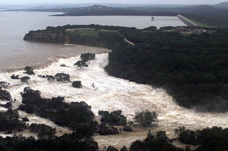
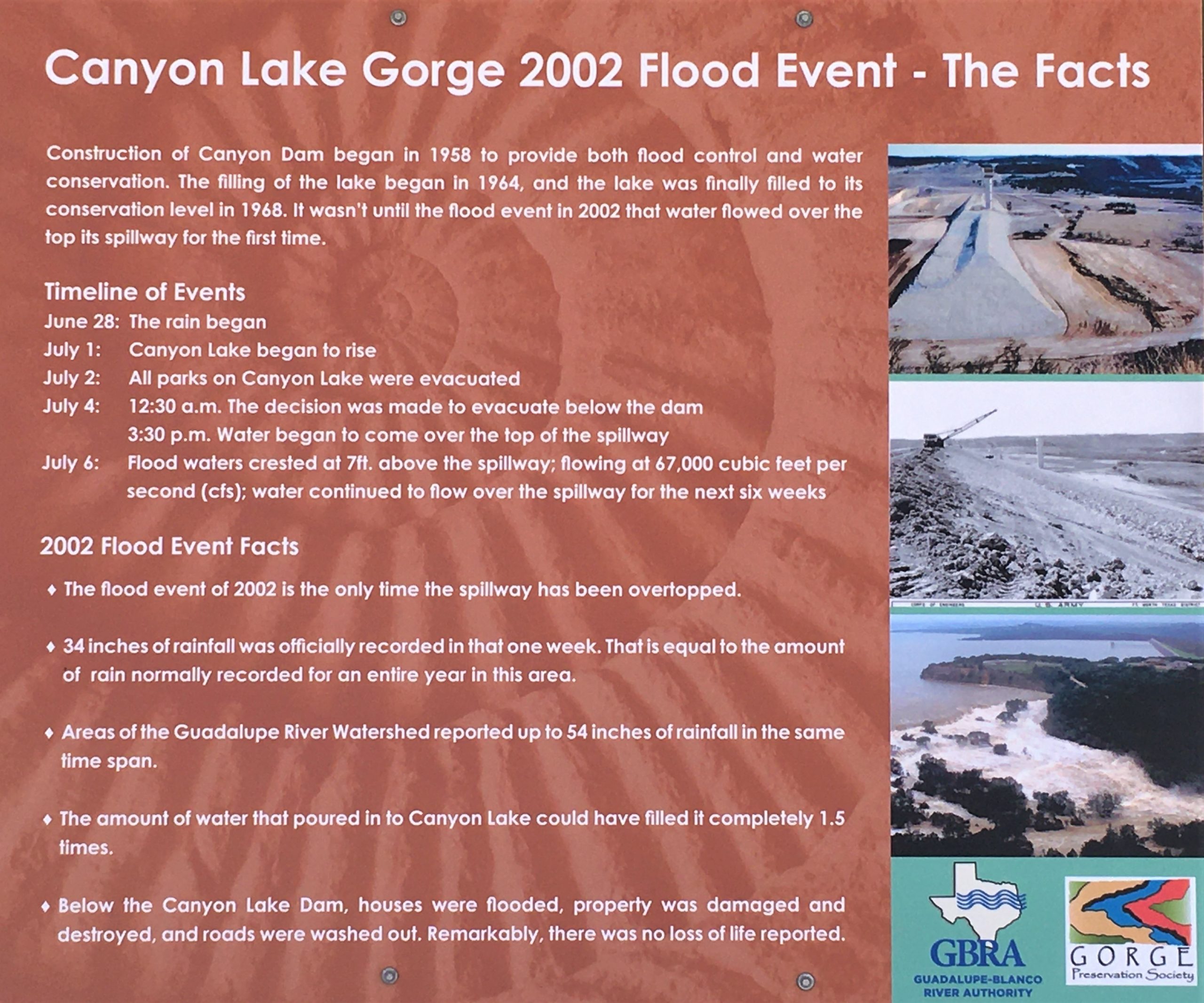
In 2002, it rained 34” here in just one week. That’s the average annual rainfall in this area. The velocity of the water was so great, it took 1/10th of a second to go 1.3 miles! Can you imagine something moving that fast?!? And at its peak, it rose 7’ above the spillway, and continued spilling over for the next six weeks.
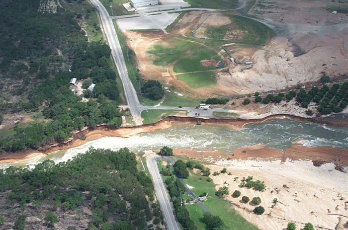
When it was all said and done (there’ll be more details later), the water pounding over the spillway for Canyon Lake, tore as much as 40’ feet of topsoil and rock away in just three days, leaving this gorge and exposing all kinds of ancient fossil stuff, including some dinosaur prints.
According to the office staff, it only took a couple of days for the geologists and archeologists to show up. 😊
Here are some same, as well as additional, facts I dug up:
The 2002 flood, beginning July 4, was the first time that floodwaters flowed over the Emergency Spillway since the Reservoir was completed in 1964.
The upper part of the Guadalupe River Watershed officially received 34 inches of rain in approximately one week.
All lakeside and River Road campers were evacuated and parks closed.
When the floodwater was at peak flow, it was moving at about 67,000 cubic feet per second (cfs) approximately 7 feet above the Spillway. Normal flow from the reservoir is 350 cfs with a maximum release of 5000 cfs.
Just under 1-1/2 times the amount of water stored in the lake (at normal level) went over the Spillway during the flood event.
Water continued to flow over the Spillway for approximately 6 weeks. Rocks, trees, logs, and other flood debris piled up in the Guadalupe River and created a huge blockage. Flooding continued from the dam to the Gulf Coast. ~ gorgepreservationsociety.com
All that information, especially about the amount of water stored in the lake, means nothing unless you know how big the lake is. It has 60-80 miles of shoreline and averages 43’ deep, but is up to 135’. This all depends on which source you read. For some reason, the facts seem to vary. Weird. Facts are facts, aren’t they? Just goes to show, you can’t always take things at face value on the internet. Are you surprised? You shouldn’t be. 😊
Below are some incredible pictures I found online:


It’s been twenty years since that flood, and they’re just now opening a trail to see the gorge. That seems like a long time! I had a hard time getting that into my brain, until I asked one of the staff a question about something and he said, “I don’t know, I was eight.” 😊
Here’s a sample of the remarkable views we had today. It’s so amazing to think of what happened here, and to wonder what the people living on the hill thought as they watched all this unfold. But who knows? Maybe the houses weren’t there then . . .


At each stop, we took a picture of the sign, and what we were looking at.
Enjoy your hike!

These are for those who take the guided tour down into the gorge.


You couldn’t see much until you got to your next stop and walked to the edge of the gorge.


Can you imagine sitting there riveted to the water raging below you?
Or were they evacuated? I have no idea.
All I can say is, if I lived there, I’da wanted to see it! : )


Good way to keep the young ones engaged! : )

Compare this picture with the on-line picture I shared previously.
Can you imagine all that water gushing over the top and rampaging through the area?

Compare this picture we took with the previous aerial view.

This isn’t the steepest hill we had to climb today, but it’s a decent example.
