Today was site-seeing day.
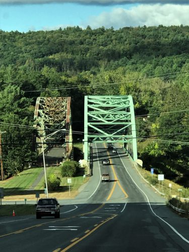
The State Line bridge for Vermont and New Hampshire.
It’s a good thing we don’t have to go through customs every time. We crossed it a lot. : )
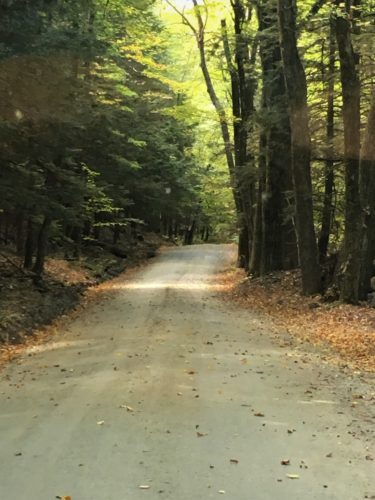
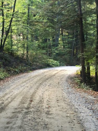
Once again, it was supposed to be an easy day, just driving around checking out the scenery, finding covered bridges, and a couple short easy hikes. But once again, we started off in a place where we bit off more than we wanted to chew. First up on our agenda, The Hawk Watch Trail in the Putney Town Forest. It was advertised as an easy trail, but it certainly wasn’t. Especially after the past two days.
We began by going in search of the Hawk Watch Trail at the Putney Town Forest.
The drive there was beautiful! Lots of farm land of various types. We had seen a sign with an arrow saying, “Putney School” and we kept thinking, there can’t possibly be a school out here in the middle of nowhere! But after several miles, there it was! Right between a horse farm and a cattle farm! I didn’t get a picture of the school because it was set so far back off the road and behind a bunch of trees, but we could tell it was fairly new and contemporary-looking.

The horses

The cows
We continued our drive and eventually arrived at the Park.


I took this while waiting for Blaine to try and decipher the map.
The trail he’d chosen wasn’t on it . . .
We began by going in search of the Hawk Watch Trail at the Putney Town Forest.
Blaine had found an actual trail name, but it wasn’t listed anywhere. Not on the board, not on the trail markers. So we chose a trail and started up. It wasn’t as difficult as the previous days’ journeys, but still . . .
When we reached the top, we figured out why it was called Hawk Watch (even though that wasn’t the official name). There was a group of about 8 sitting up there in their lawn chairs, with binoculars glued to the skies. There was a glassed board with bird sightings listed. The most outstanding one being that on September 17, 2017, they spotted a record 3,000-and some! That’s a lot of birds for one day! It’s not just hawks, they also count osprey, eagles, vultures – all the birds of prey.
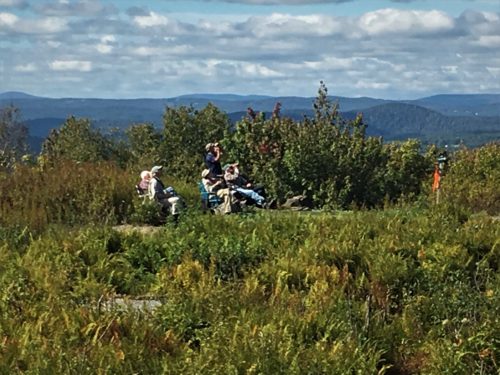
These are the Hawk Watchers.
Not a good quality picture because I didn’t want them to think I was standing there taking their picture.
Even though I was . . .
There were two really interesting aspects to this trail. First, we spotted a tree that had been hit by lightning.


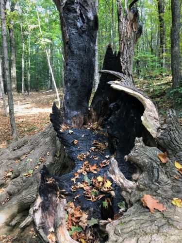
A lightening strike!

The other was the sign about sheep being brought here to graze. Of course, being animal-repellent, we didn’t see anything, but check it out:

Really?? Sheep?
Didn’t expect that!

Shepherding supplies have certainly changed over the centuries!
The views from the top were nice too!


This saying was on their bulletin board

Aren’t these beautiful?!

Blaine thought this was really interesting, how it just seems to have twisted around
As we returned to the Jeep to head on down the road, I asked Blaine if we could please return to a barn and silo we had passed on our way here. I didn’t get a picture when we went passed it the first time because we were going too fast, but he agreed to go back. It added 10 miles to our day, but I think the picture was worth it! What do you think?

We returned to the road the Park was on, but this time, when we turned onto the road, we noticed a sign stating this was a “Seasonal Highway”. It was not like any highway we’ve ever been on – seasonal or not – but it sure was beautiful. 😊

Next up was the Williamsville Covered Bridge. A tiny bit of a disappointment because it was re-built, but it’s still pretty cool.

The Willimsville Covered Bridge
This one was re-built 7 years ago

Vermont is known for all its covered bridges.
HOWEVER – when I went in search of details, I found this on the National Society for the Preservation of Covered Bridges website, dated 2017. Seems like they should know whereof they speak.
This page was compiled from a variety of sources to provide you with examples of routes for visiting covered bridges in various areas throughout the country.
Some links point to external websites. Please let us know if you run across any that no longer work.
Why are bridges covered?
Many reasons are offered for covering bridges such as providing shelter during inclement weather or so horses wouldn’t be afraid to cross the water. However, the real reason is to protect the structure supporting the bridge. Without protection from the weather, the wooden timbers supporting the bridge would decay and eventually collapse. By keeping them dry, they will last much longer.
When was the first covered bridge in the U.S. Built?
The earliest documented covered bridge was the 550′ Permanent Bridge constructed over the Schuylkill River in Philadelphia by Timothy Palmer in 1805.
Where is the oldest covered bridge still standing in the U.S.?
The oldest documented American covered bridge is the Hyde Hall Bridge in Glimmerglass State Park near Cooperstown, New York. It was built in 1825.
Where is the longest covered bridge?
- The longest existing covered bridge is the Hartland Bridge built in Hartland, New Brunswick, Canada at 1282′. The bridge was built in 1901 but not covered until 1922.
- The longest American covered bridge is the Smolen-Gulf Bridge built in 2008 in Ashtabula County, Ohio at 613′
- The longest historic American covered bridge depends on how the length is measured. The Cornish-Windsor Bridge over the Connecticut River between Cornish, New Hampshire and Windsor, Vermont and Medora Bridge in Medora, Indiana can both claim this title. The truss of the Cornish-Windsor Bridge is longer than Medora’s 449.5′ vs. 434′. The span (distance between the faces of the abutments) of the Medora Bridge is greater than Cornish-Windsor’s, 430.4′ vs. 422′. For more details on this topic, visit the Medora Bridge page.
Which state has the most covered bridges?
Pennsylvania has the most with 213. Ohio is second with 148.
Which county has the most covered bridges?
Parke County, Indiana with 31.
We were both quite surprised!
FYI – at its peak, Ohio had over 4,000 of them! As far as Vermont goes, it’s ‘claim to covered bridge fame’ is that it has more per square mile than any other state –they have just over 100 total.
Here’s an original covered bridge from 1872 – the Dummerston Covered Bridge. At 280’, it’s the longest covered bridge entirely within the State of Vermont. (The longest one is 460’, but crosses state lines into New Hampshire)

The Dummerston Covered Bridge
Built in 1882, it’s the longest one in Vermont, and still gets lots of traffic.

Under the bridge

Gorgeous!


Did you notice how the two sides were different colors?
That’s the power of the sun!


Some flowers by the road
I was trying to find how to pronounce Dummerston. “Dumber” just didn’t sound right, so we thought maybe “Doo-mer”. I never found out, but here are some facts I uncovered on the town.
The town was named for William Dummer of Massachusetts, who was one of three sons of Jeremiah Dummer, a wealthy and politically prominent 17th Century Boston silversmith, artist and magistrate. In the early 1720’S William Dummer became chief magistrate of Massachusetts, and one of his many accomplishments in that office was a treaty with the Indians which kept peace in the colony for almost twenty years.
When Connecticut sold the Equivalent Lands at auction in 1716, William Dummer and William Brattle, whose name was given to Brattleboro, bought part of the area that now makes up Dummerston, as well as some of the adjoining towns. In 1723 the Massachusetts General Court voted to build a fort north of Northfield, Massachusetts, to protect the frontier settlements. A fortified blockhouse was built the following year at a cost of £256 and named Fort Dummer in honor of William Dummer, who was then lieutenant governor of Massachusetts, and in fact was acting governor at the time. The site of the fort, which was demolished in 1763, is well over the line in Brattleboro, and now under the waters behind the Vernon Dam.
Next, we stopped in Brattleboro looking for a Subway (Blaine had a craving) and a place to eat. I wanted to go to the local park a resident told me about, but Blaine wanted to watch the city. He wanted to sit on a concrete bench at a fountain right in the center of town – and the center of the intersection. Nope. Not me. We compromised and sat on a park bench we found that was off the street and behind the fountain.
Here’s our lunch view . . .
And a couple of buildings where we parked in the street.

More buildings in town

A building in Brattleboro
After lunch, we went in search of Fort Dummer State Park and an easy trail Blaine had found out about. Most of the Park was closed, but we walked the trail. I’d be lying if I said I wasn’t disappointed.


I thought we’d see an actual fort – or at least the remains. Instead, here’s the view from the trail. : )

Here’s the view of the Fort
It was on that island down there.
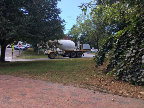
We had to drive through Brattleboro again to get home and I snapped a couple of pictures.

The streets of Brattleboro


And then – What in the world is THAT??
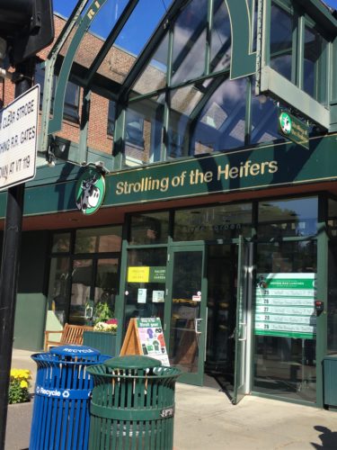
OK. So what in the world is that????
Google really is a wonderful thing . . . 😊
The Inspiration
“Orly, you have to do something about this,” Dwight Miller told his neighbor, Orly Munzing, back in 2001 as they strolled through Miller’s Dummerston, Vermont orchard.“Farmers are slowly going out of business. People don’t know where their food comes from. If they knew how hard farming is, they’d support their local farmers.”
Munzing took Miller’s words to heart, and then she had an inspiration. She had recently visited Pamplona, Spain, site of the famous Running of the Bulls. As a way of honoring and supporting local farmers, she envisioned a slower, friendlier, female version of the Running of the Bulls — the Strolling of the Heifers. Farmers would bring their heifer calves, lead them up the historic Main Street of nearby Brattleboro, and afterward, there would be a festival where people could meet the farmers and learn about local foods.
A parade turns into a movement
Munzing went to work with a team of volunteers, and the first Strolling of the Heifers parade and festival took place in 2002. The word “locavore” had not yet been invented (it came along in 2005). But from the beginning, the point of Strolling of the Heifers was to support and sustain family farms by connecting people with healthy local food, and by showcasing the farmers and food producers who bring it to them.
Now in its second decade, Strolling of the Heifers has grown from a small-town parade into a regional movement with year-round programs and events. In recent years, “the Stroll” has expanded its horizon to include not only sustainable agriculture and food systems, but many other aspects of local economic sustainability.
There are several videos of the parades on Youtube if you’re curious. They really do walk the cows down the middle of the street. 😊